With the new map, we are building a bridge between these worlds. By automatizing cartographic techniques used to create analogue maps, we can process the entire OpenStreetMap planet (the only data basis for the new map), without manual interference. These techniques have long been established and serve to optimise the readability and usability of a map. Nevertheless, they tend to be neglected in state-of-the-art web maps. One thing is clear, however - what makes a good map applies to both analogue and digital maps. Here is some brief background information for context:
Background
For centuries, cartography as a scientific discipline has been concerned with methods of conveying extensive and, above all, relevant, interrelated spatial information accurately on an abstracted scale. Naturally, the available space is the limiting factor and one of the main challenges for creating a map. Thus cartographers such as Eduard Imhof and Jaques Bertin, especially in the 20th century, developed a set of rules summarised by the term cartographic generalization. It contains techniques that enable the cartographer to depict relevant information in an easily understandable and aesthetically pleasing way on limited space. For a long time, it was the mastery of these techniques that made a good map.
With the advent of ever more powerful computers, greatly improved surveying technologies, satellite-based positioning systems and the Internet as a carrier medium, a new era for cartography began and suddenly highly detailed, multi-scaled maps covering the entire planet are ubiquitous and available in virtually every pocket. As astounding as this development is, it has not come without its drawbacks. Driven by visionary software and web developers, the old generalization techniques of cartographers have largely disappeared and thus far haven’t found their way into state-of-the-art web maps, which in their turn have largely replaced traditional, paper-based maps.
Generalization Techniques
To illustrate this, I will highlight six selected generalization techniques and examine for each how and if at all it is addressed in conventional web maps and how our implementation differs in the new maps of the Rother App.
Selection
This generalization technique denotes the process of removing certain objects or entire object classes which the cartographer considers unimportant for the given scale and purpose of the map. Selection is the most important generalization technique and is used in pretty much all OSM-based web maps.
Today’s web maps usually rely on simply excluding entire object classes as the scale decreases (i.e. as one zooms out from a smaller area to view a larger area). For example, above a certain scale all residential streets or names of cities with a population below a certain threshold would be hidden. The problem with this approach is that the selection of objects to be shown should also be dependent on the objects in their vicinity. For example, if the density of the road network is very thin or if major roads are lacking, it is desirable to show smaller residential roads. Similarly, in a sparsely populated rural area it makes sense to show smaller towns that are less relevant in a densely populated area.
In relation to roads, our approach is therefore to take the density and connectivity of the road network into account and use a suitable algorithm to thin it out, instead of excluding entire road classes. In this way, an appropriate density of information is achieved, which supports the readability and usability of the map.
Simplification
Simplification is used to reduce detail in shapes that could otherwise not be depicted properly with decreasing scale (and relatively increasing line width). This generalization technique is used in all web maps. However, the motive behind it is not so much the increase in cartographic quality as it is the decrease in data size.
The algorithm commonly used is the well-known Douglas-Peucker simplification. It removes relatively redundant vertices from a line while retaining the outermost vertex of an arc, resulting in sharp bends. This effect is particularly prominent for roads winding up a mountain pass in serpentines. In web maps, these often appear as a series of sharp jags, which in extreme cases can no longer be perceived independently. When generalizing the data, we therefore used the Wang-Müller algorithm, which identifies and eliminates relatively insignificant bends while retaining the general character of the road.
Merging & Displacing
If several relevant objects are so close to each other that they cannot be displayed independently, the rules of generalisation state that they should either be combined or displaced. If they are objects of the same type, they should be combined into one object. If they belong to different types, they should be moved apart until they no longer overlap.
Both merging and displacing are techniques that have not yet found their way into modern web maps. To a large extent, this is certainly due to the complexity of the algorithms required, but also to the huge computing effort needed to run them on a global data set.
Nevertheless, we tried our hand at it and applied it to the European road network. Even if the automation of this technique does not yet work perfectly, you can still find some successful examples. Particularly in narrow valleys or along lakes, there are often several transport routes - such as roads, railways and hiking trails - close to each other, so that in most of today’s web maps they overlap considerably and often disappear under the higher-ranking ones. In such cases, we combine multi-track railways or multi-lane roads into one and displace them to such an extent that both can be shown independently.
Collapsing & Exaggerating
These last two generalization techniques are used when a linear or planar object is too small to be clearly visible, but too large to be overlooked. Like the two previous techniques, this generalization technique is not being applied to modern web maps. The effect is best illustrated by the example of roundabouts.
Roundabouts have a certain relevance as they are characteristic features of a road network and often serve as landmarks. It is therefore desirable to clearly depict them on the map if the scale is appropriate and space is available. However, if they are too small or unimportant for the given scale, they should be removed completely. Otherwise they will appear as "unidentifiable knots" and unnecessarily interrupt the road network, as is often the case in non-generalized maps.
We have also succeeded in automating this process . In our solution the first step, now fully automated, is to collapse all roundabouts that fall below a certain diameter into regular junctions. We have also succeeded in automating this step. Firstly, all roundabouts that fall below a certain diameter are converted into regular junctions. Then we test whether the remaining roundabouts can be displayed as independent circles with a recognisable "hole" in the middle. If this is not the case, they are replaced by circles of the appropriate size. This results in a clean streetscape in which characteristic roundabouts are clearly recognisable.
The generalisation techniques highlighted here are cartographic subtleties that are not immediately apparent to the map user, but which significantly improve the readability and usability of the map. We see the map of the Rother App as a central element of the user experience design, which is why it is important to us to pay attention to seemingly small details and improve them. The good news is that research on the attributes of these improvements has been available for decades and the improvements have been formalised into the principles of cartographic generalization.
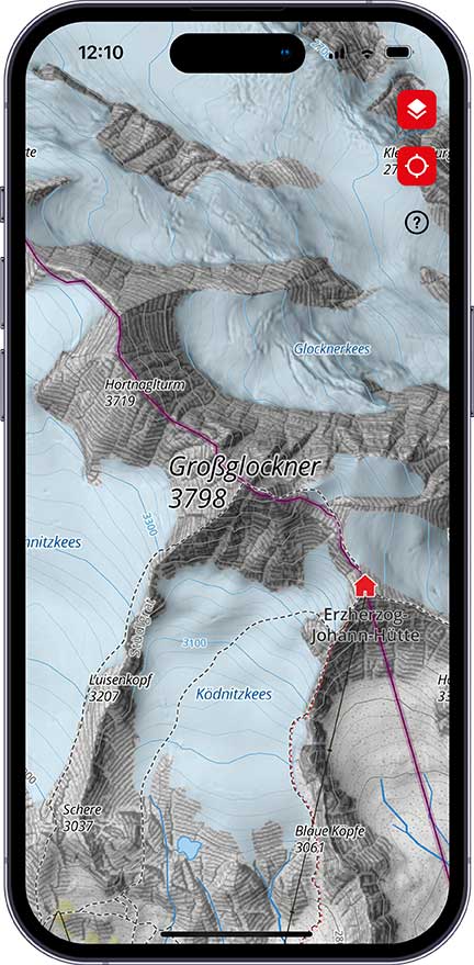
Terrain depiction
A much more obvious change in the new maps concerns the improved terrain depiction. Here, too, we draw on established cartographic techniques from the analogue world and try to automate them. We benefit considerably from the work of the Swiss cartographer Roman Geisthövel, whose research centred on the automation of rock depiction in the style of the Swiss national map. The so-called rock drawing in cartography is a technique developed primarily in the Alpine regions of central Europe and was brought to perfection in Switzerland to depict very steep and rugged rock formations that cannot be adequately represented by conventional means such as contour lines.
Despite advancing automation, the creation is still very time-consuming, which is why the improved terrain depiction and in particular rock drawings are initially only available for the Alpine region. Other areas will gradually follow.
New technologies in the field of surveying also allow us to access greatly improved data in the form of high-resolution elevation models. Well-known contemporary cartographers such as Tom Patterson and John Nelson use these elevation models to generate impressive terrain visualisations with the help of modern computer graphics in the field of raster processing. We also use many of their techniques to put the finishing touches on the terrain depiction.
Download now for free - Rother App
We hope you enjoy using the new maps as much as we enjoy creating them, whether it's to find inspiration for your next tour, to plan it or to navigate the terrain. Although a map should first and foremost be a well-functioning tool, we strive to make it be a pleasure to your eyes and an invitation to dream.
The new maps are now available free of charge in the Rother app. For Android, iPhone and online on www.rother.app.
Most important facts:
- Accurate and clear maps for navigating the terrain
- Three-dimensional depiction of the terrain
- Marked hiking trails are clearly highlighted and labeled
- Downloadable for offline use
- Available as a hiking and cycling map
- Free of charge in the Rother App

