Geopsis-Karte 131, Eastern Rodópi 1:40.000
Nordgriechenland
Tags
Östliche Rhodopen
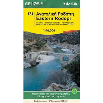
Eastern Rodopi Mountain Range Map 1:40.000
Wild horses, the largest old stone bridge in Eastern Macedonia and Thrace, stunning scenery – Eastern Rodopi is a hiker's paradise! It features natural wonders like the Thracean Meteora and archaeological remnants due to its cultural and religious significance. On the foot of the mountain passed the famous Via Egnatia of the Roman empire. This is a hiking, biking and MTB, road and touring map.
- 70x100cm, folded 12x24cm, Scale 1:40.000
- Printed in the waterproof and indestructible material 'POLYART'
- Back side featuring more info and maps
- 9 proposed hiking routes
- This map covers Mt. Papikio, Thracean Meteora, Kompsatos River, Nymfaia Forest, Chionorema, Strymi and Pomak Villages
Publisher:
Series:
Scale:
1:40.000
Product Type:
Maps
Language:
English, Modern Greek
EAN:
9789609960243
Year of publication:
2014
Write Your Own Review
No manufacturer information and safety instructions available yet.