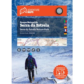
Adventure Map Serra da Estrela 1:25.000
höchstes Gebirge am portugiesischen Festland

Tags
Map of Serra da Estrela Nature Park
Legended in 5 languages (PT, EN, ES, FR and DE), it includes the whole network of pedestrian walks in the Park, tourist attractions such as mountain villages, thermal baths, river beaches, waterfalls, camping sites, picnic areas , ski slopes, tourist offices, among others.
It also includes the localities of Covilhã, Gouveia, Manteigas and Seia.
Printed in waterproof and anti-tear film
Resistant to frequent handling
- Scale: 1/25 000 (1 cm = 250 m)
- Legend and Additional Information in Portuguese, English, Spanish, French and German
- Built-in magnetic compass
- Road network (includes GR22 and GR33)
- Tourist points of interest with symbols such as: Mountain Villages, Waterfalls, Panoramic Views, Picnic Areas, Museums and Tourism Stations, among others
- Equidistance of contour lines: 10 m
- Gauss Quadricula with divisions of 1 Km
- WGS84 coordinates (compatible with GPS)
- Representation of the magnetic declination
- Open Dimension: 96.5cm x 62.7cm
- Folded Dimension: 21cm x 15.2cm
- Printing: double-sided with overlapping area
- Waterproof and anti-tear film
Weight:
57 g
Publisher:
Series:
Scale:
1:25.000
Product Type:
Maps
Language:
English, French, German, Portuguese, Spanish
EAN:
9789895405206
hoehe_mm:
210
breite_mm:
152
hoehe_mm_offen:
965
breite_mm_offen:
152
Year of publication:
2018
Continent: Europe
Country: Portugal
Region: Serra da Estrela, Nordportugal
Places / Mountains / Lakes: Torre (Portugal), Manteigas, Gouveia, Seia, Covilhã, Loriga, Valezim, Sabugeiro, Folgosinho
Write Your Own Review
No manufacturer information and safety instructions available yet.


